
Google, along with the U.S. Geological Survey, NASA, Time magazine, and Create Lab at Carnegie Mellon University, teamed up to launch a new project that showcases how the Earth has transformed over the last 28 years.
This endeavor, called Timelapse, displays environmental changes of the planet.
 “Users can go back in time and get a historical perspective on the changes of the Earth’s surface over time,” Google said in a blog post.
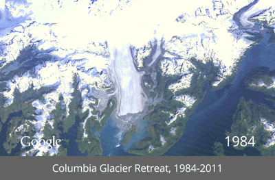
Browsers can view the Colbumbia Glacier Retreat, Dubai Coastal Expansion, Las Vegas Urban Growth, and Brazillian Amazon Deforestation.
Millions of satellite images taken from 1984 to 2012 by the Landsat Program, a partnership between USGS and NASA, were compiled to create a timelapse. Every frame of the timelapse map is made from a year of satellite data.
Google began collaborating with USGS in 2009 to make an archive of earth imagery. With Google Earth Engine technology, Google combs though over 2 million images to find the highest-quality pixels for every year since 1984. Next, the images were then compiled into planetary images. Lastly, Create Lab at Carnegie Mellon University was brought into the project to convert the annual Earth images into a seamless HTML5 animation.
What Google is striving for with this undertaking is to enlighten the global community’s assessment on how we utilize our planet and ways to secure the stability and resourcefulness of the Earth for future generations.